 Industrial and agricultural centre situated 8 km from Reggio Emilia
Post Code: 42011
Telephone area code: 0522
Market day: Fridays
Annual Fairs: First Sunday of September and on the celebration of the town's Patron Saint's day on 2 April
Distance from Reggio Emilia: 8 km
Outlying Villages: Pieve Rossa, San Michele, San Tommaso della Fossa
Inhabitants:
9.192 update Dicember 31, 2007 |
How to get there:
By car : the A1 motorway exit Reggio Emilia , take the Provincial Road (SP3) direction of Bagnolo in Piano.
From the Reggio Emilia main train station take the local "ACT" service between Reggio Emilia and Guastalla. |
Tourist information:
phone 0039 522 957411; fax 0039 0522 951037 - town council |
The first evidence of human settlement in the area dates from the 2nd century BC. This was contemporaneous with the gradual process of land reclamation from a vast marshy area which originally extended north from Reggio Emilia to the river Po called the "Bondeno".
In the period between the 11th and 14th centuries the area remained under the jurisdiction of the Benedictine monks of the San Prospero monastery. In 1335 the monastery was destroyed and the land passed to the Gonzaga family. Later the town came under the rule of the Este family of Modena, continuing up to the end of the 18th century. Their rule was interrupted by the well-known series of events connected to the French Revolution. During this latter period the local council area was split in two (Bagnolo and San Tommaso), both parts then to be united with Reggio Emilia in 1814. These days Bagnolo in Piano displays a renewed confidence and belief both in its past and its future, with the recovery and protection of its historic past on the one hand and its development of modern architecture and town planning on the other.
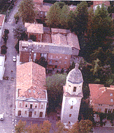
The town's most important historic building is the Torrazzo, symbol of the Comune (the local government). Building began in 1354 on behalf of the Gonzaga family as a fortification and defence of the roads joining Reggio Emilia and Mantua. It was destroyed by invading French troops in 1702 (only the tower or keep now remaining). The following are also of interest: 18th-century parish church dedicated to San Francesco da Paola (the town's patron saint), the 12th-century church dedicated to the Santissima Immacolata Concezione (the Immaculate Conception) at Pieve Rossa in the village of Fossetta and the "Cà Rossa" rural estate dating from the 17th century.