 The Town of Rolo is situated in the plains of Reggio, 28 kilometres from Reggio Emilia
Postal code: 42047
Open-air market held on Mondays
Feast of Santa Vincenza and San Zenone, Patron Saints of Rolo, on the third Sunday in June
Outlying village: Tullie
Inhabitants:
3.984 update Dicember, 31 2007 |
How to get there:
.Distance from Reggio Emilia: 28 km. Distance from the Reggiolo-Rolo exit of the A22 motor-way: 4 km. When coming from Reggio Emilia, take Provincial Road SP 5 travelling in the direction of Novellara and Reggiolo, and turn off in the direction of Villanova and Rolo.
Rolo Railway Station |
Tourist information:
Town Hall 0522658011 |
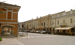
Situated in the northwestern plains of the Province of Reggio Emilia, Rolo was called Ariolas in ancient days. It was mentioned for the first time in a Lombardic charter dated 772. The town name derives from the Latin "areola", meaning "small area", a term which was probably used in reference to a cultivated area in the midst of woods, or other uncultivated land. However, the area did not become populated until the time of the Romans. Archeological discoveries from that period show that there were scattered rural settlements in the area, due to the agricultural potential of the terrain. The territory was almost certainly governed by the Roman municipality of Regium Lepidi. During the Middle Ages, the inhabitants tended to gather into small villages, which were easier to protect by the erection of fortifications if necessary. A notorial document dating back to 902 records the existence of a village named Vico Rolesa. From the 15th century to 1776, Rolo was a small, independent village governed by the Sessi family. Between the 18th and 20th centuries, the art of wood inlay developed in Rolo; today the small tables called "rolini" are well-known. The present-day town of Rolo is characterised by a long tradition in manufacturing, especially in the agricultural machinery, staircases, agricultural industries, and textile sectors, along with the more recent plastics sector.