Official Tourist Information Site of the Municipality of Reggio Emilia
MONTECCHIO EMILIA
 Montecchio is an important business centre, situated in the lower part of the Enza Valley. The ancient town of "Monticulum", located at the crossroads between the roads through the foothills and the road from the Apennine Mountains to the Po River along the course of the Enza River, was for centuries a strategic town of considerable importance. It was situated along the main road running north and south even before the time of the Roman conquest, as shown by archeological finds from the prehistoric and protohistoric periods.
Weekly open-air market every Monday
- antique market every fourth Sunday of the month
- postal code: 42027
Inhabitants:
10,021 update December 31, 2007 |
How to get there:
Distance from Reggio Emilia Km 16
By car: from Reggio Emilia take the secondary road to Montecchio Emilia.
Public bus service from Reggio Emilia to Montecchio Emilia |
Tourist information:
Municipality phone 0039/0522/861811 - Fax 0039/0522/864709 |
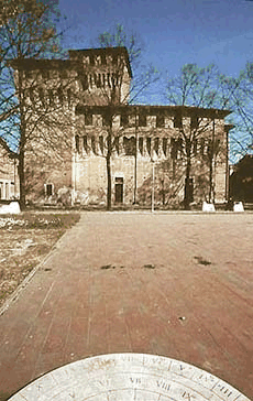
The Lombards also settled in the area, and as early as that period all of the Enza Valley was subject to the influence of different sovereigns, who were often in conflict. In 781, the borderline between the dioceses of Parma and Reggio Emilia was located at Montecchio. During the Dark Ages, Montecchio served as a fortification protecting the central part of the territory belonging to the Canossa family. This role is confirmed in documents from the monastery of Sant'Apollonio of Canossa and Matilda, Countess of Canossa that sanctioned control over the locality by the church. With the decline of the bishop's authority, the Municipality of Parma exercised its control over the area. In 1296 the oldest fortifications were razed to the ground by Azzo d'Este. Around the mid-14th century, the family conflicts in the context of battles between seignories (the Este, the Scaligeri, and the Visconti and their allies) concluded with the subordination of Montecchio to the authority of the Visconti. With the fall of the lords of Milan, the House of Este's dominion reached as far as the Enza River, remaining in force until the Unification of Italy (1861), except for brief intervals. Beginning in the latter part of the 15th century, the Este rebuilt the Montecchio Castle and the town fortifications. In 1453, Borso d'Este allowed Montecchio to draw up independent statutes, since the town had possessed its own coat of arms since 1442. This consisted of a diamond ring, and symbolized everlasting union with the House of Este. Following this, Montecchio was granted ample authority over the territory from Barco to Sant'Eulalia (present-day Sant'Ilario), a boundary which remained unchanged until 1859. Throughout the first twenty years of the 16th century, the Municipality of Parma continued to claim the area. At the same time, a period of rule by members of local families who had risen to the top of the economic and social ladder began. Beginning in 1680, conflict between the great European states caused in Montecchio, as in other areas, repeated periods of military occupation, fiscal oppression, and political humiliation, weakening the town's age-old independence.
During the Restoration Period after the return to power of the Austrian-Este alliance, many citizens of Montecchio participated in the uprisings of 1821 and 1848. By the end of the 19th century, the construction of a bridge over the Enza River and the railway from Reggio Emilia to Ciano (1909) made the first phase of economic development in Montecchio possible. Development continued with the creation of industries related to agriculture, dairy products, the cultivation of vineyards and the production of wine. Today Montecchio is a modern town with various industries and services, which preserves important monuments from its past.
Last update: 21/05/2011

SITur
Tourist Information System